
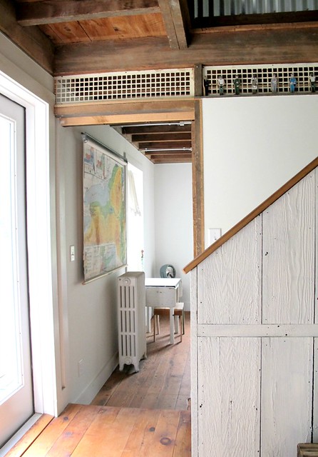
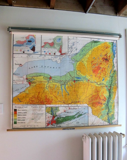
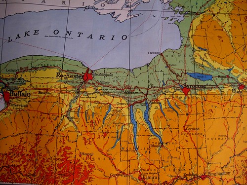
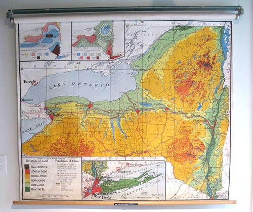
My mother scored a gorgeous vintage school map of the state of New York. Last week she hung it up in her barn's downstairs bedroom, where my children sleep when they stay over. We were all so excited, and it got me thinking about the role maps have played in my life.
My sense of the world, and even the United States, was fuzzy until I met my husband, a map aficionado. I had always been a good student, but without the constant visual of maps, my sense of location wasn't my strength. He changed all that when he handed my a Rand McNalley Road Atlas
-Peters Projection World Map
"All the countries of the world are represented at true size and true proportion. This is one of the few commercially available maps that is fair to all peoples. Most maps drastically enlarge the size of the Northern hemisphere countries and diminish the size of the Southern hemisphere countries. This traditional bias leads most people to overestimate the importance of the developed nations based on their inflated appearance"
-Melissa & Doug's License Plate Game 2098
-Floor puzzles of the world and our country are always popular... we have several.
-Map placemats- we love educational placemats at snack time.
-GEOGRAPHY: This is a favorite road trip game once a child has a general knowledge of reading and geography. Start with any place in the world-- "Camaroon", for example. The next person has to think of a place that begins with the last letter of "Camaroon," such as "New York." Whoever goes next needs a place that starts with an K. You may not use the same place twice in a game--and it has to be a real place.
A few book suggestions:
- Bread, Bread, Bread
any and all of Anne Morris' series Around the World
- Children Just Like Me
- My World- From the Seven Continents to The Seven Seas, From Katmandu to Kalamazoo
- Me on the Map
- Mapping Penny's World
- DK First Atlas
- National Geographic World Atlas for Young Explorers

We recently picked up a license plate game from Melissa & Doug. It is a US map with a license plate tile for each state. The tile has the plate on one side and the state name and capitol on another. It has brought all kinds of fun on our summer road trips for my kids (7 to 12 y.o.) The level of detail is akin to the state puzzles, so not in depth but a fun way to bring a little geography in and an incentive to tune into the trip!
ReplyDeleteI used to play that game on journeys with my grandparents! We would also do the alphabet version, where first you would have to say something beginning with 'a' {Australia}, and then 'b' {Bognor}, c {Calgary}, d {Denmark}, and so on.
ReplyDeleteI've found that I will, when explaining countries, use the size of atlas I'm used to at school, and just point in the air to the area. It's a silly habit, but helps me remember where countries are.
Libby- I love how your atlas remains in your mind for explanations!
ReplyDeleteSusan! I had forgotten all about that license plate game... we have it too... it's in our car! I'm going to add it to the list. Thanks for the great reminder!
ReplyDeleteI really should get a map for my kids, the eldest (4) is just beginning to understand the concept of our planet. I used to have a beautiful globe when I was young, I would pour over it for hours.
ReplyDeleteLove these... and I'm thinking I may try to make my own with a paper map and a pull down window shade (cheap-o that I am!)
ReplyDeleteLinzi- globes are wonderful ways of exploring the world for any age! Four is perfect.
ReplyDeleteGrace- I would just call you clever and resourceful! great idea!
I'm coming back to study the links in this post....two years ago, I scored four roll-down school maps from a board of education warehouse sale. (they were 50 cents!) But I hung a US map in my oldest daughter's room. And I am amazed at how much she learns just by lying in her bed staring at the map.
ReplyDeleteOh, laminated. Duh, what a good idea. Our US map (in the hallway) is sort of in tatters around the edges. The world map (dining room) is faring a bit better. We also used to have a shower curtain with a map of the world--it was a vinyl one and after too many washings it sort of fell apart--but my son learned so much from the shower curtain! I love maps and atlases and still like to have a map in the car and written-out directions, with the GPS only as backup. (And often, the Garmin steers me wrong anyway--I prefer a map!)
ReplyDeleteWe also love maps. I am currently updating our poster/map rotation. A few years ago, I missed out on a set of school pull down maps. Oh, how I wish I had those.
ReplyDeletemolly- my son had one next to his bed for a few years, too! It did the same trick, but it didn't last his cover tossing and wild feet and moved to over his desk... which he doesn't sit at nearly as much as hang out on his bed. sigh.
ReplyDeleteamy- map lovers unite!
proudmama- great idea to rotate maps!
ok... I'll be back later to check in but the sun finally came out!
Love it!
ReplyDeleteBy the way, you can find really beautiful vintage maps on etsy. I found one from the 1800's of Northern California for my dad, who now lives in Germany. It's such a nice gift for someone who is homesick.
xo
i think you would love Peter Mentzel's Material World and Hungry Planet... big beautiful photographic books about what folk own and eat around the world... I blogged about them here:
ReplyDeletehttp://www.se7en.org.za/2009/07/09/se7en-do-geography-heaps-of-resources
A favorite book of mine is "Mapmaking with Children" by David Sobel. It looks at how children understand maps from a developmental perspective, arguing for helping them map their own world before moving out into broader explorations. Great book.
ReplyDeleteI second the admiration for Peter Mentzel's books - they offer incredibly powerful messages about household consumption and ownership around the world through pictures. Well worth a read!
ReplyDeleteThank Se7en- you know how I feel about your recommendations!
ReplyDeleteLiz- I'm definitely going to hunt down Mentzel's books. sounds like something we'd love.
Sara- Lobel's book looks wonderful!
Just one more note on the Mentzel books... I didn't realize it was the same Material World that we have already... thought it was a children's book! We also have Women in a Material world which my kids have always loved because there is an emphasis on mother's and children. We don't have Hungry Planet , so I'll look into it.
ReplyDeleteOh yes! I forgot about 'Women in a Material World' - that's a wonderful one. We actually used it as a textbook in one of my college classes (on women in development). Happy reading!
ReplyDeleteWe have always had a world map on the wall next to the dining room table. I removed it once, and we missed it so much that it went up after just a couple of weeks. Map puzzles are great for learning states. So much good stuff out there.
ReplyDeleteWe just got back from a long road trip up north. We let my 8 year old daughter use the map and call out the upcoming towns. I remember doing this as a child and loving the responsibility. Love the huge map...I'm on the lookout for one too! Thanks for sharing.
ReplyDeletealways loved geography and maps and globes. i look and imagine all the people in the different places. a great post.
ReplyDeletelovely inspiration!!
ReplyDeleteHer map is stupendous!! Really digging that idea! The relationship I have with maps was borne out of very similar circumstances as what you described. My husband, whose parents were teachers, spent every summer camping cross-country with his family. Nat'l Parks and everything in between. He has quite the wanderlust, and we've been on some major roadtrips as a couple and family. I am reluctant to spend 15 hours in a car these days, but NOTHING beats seeing the United States by car!!!! Our last trek from PA to OR was spurred by donuts...yes, donuts. We ended up discovering Hood River, OR in the process and can't wait to go back. xo jan
ReplyDeleteThanks so much for the book and game list and map referrals. My kids love maps and we're always on the lookout for new ideas and inspiration.
ReplyDeleteWow! That map is fantastic! What a find. I love maps and have a few hanging around our home for the kids to dream. Thanks for all the links and ideas! You are such inspiration.
ReplyDeleteI'm a teacher and was able to score an old roll map of the US when my school was getting rid of them. My husband and I hung it in our loving room right above our couch and it looks so great! We've put star stickers on it to track we're we've been. Everyone always comments on it. It is one of my favorite pieces in our home.
ReplyDelete